
Page 26 - Ickford Neighbourhood Plan
P. 26
26 VISION FOR ICKFORD : ICKFORD NEIGHBOURHOOD PLAN : 2019 – 2033
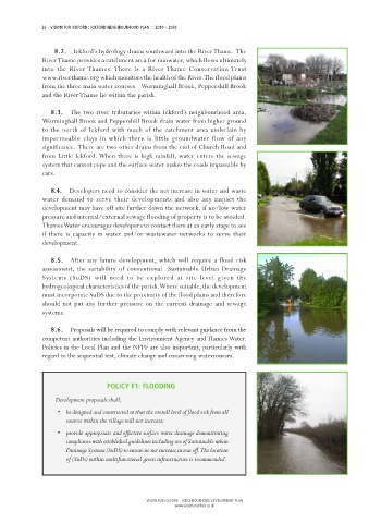
8.2. Ickford’s hydrology drains southward into the River Thame. The
8.2.
8.2.
8.2.
8.2.
River Thame provides a catchment area for rainwater, which flows ultimately
into the River Thames. There is a River Thame Conservation Trust
www.riverthame.org which monitors the health of the River. The flood plains
from the three main water courses – Worminghall Brook, Peppershill Brook
and the River Thame lie within the parish.
8.3. The two river tributaries within Ickford’s neighbourhood area,
8.3.
8.3.
8.3.
8.3.
Worminghall Brook and Peppershill Brook drain water from higher ground
to the north of Ickford with much of the catchment area underlain by
impermeable clays in which there is little groundwater flow of any
significance. There are two other drains from the end of Church Road and
from Little Ickford. When there is high rainfall, water enters the sewage
system that cannot cope and the surface water makes the roads impassable by
cars.
8.4.
8.4
8.4.. . Developers need to consider the net increase in water and waste
8.4.
8.4
water demand to serve their developments and also any impact the
development may have off site further down the network, if no/low water
pressure and internal/external sewage flooding of property is to be avoided.
Thames Water encourages developers to contact them at an early stage to see
if there is capacity in water and/or wastewater networks to serve their
development.
8.5.
8.5.
8.5.
8.5.
8.5. After any future development, which will require a flood risk
assessment, the suitability of conventional Sustainable Urban Drainage
Systems (SuDS) will need to be explored at site-level given the
hydrogeological characteristics of the parish. Where suitable, the development
must incorporate SuDS due to the proximity of the flood plains and therefore
should not put any further pressure on the current drainage and sewage
systems.
8.6.
8.6.
8.6.
8.6.
8.6. Proposals will be required to comply with relevant guidance from the
competent authorities including the Environment Agency and Thames Water.
Policies in the Local Plan and the NPPF are also important, particularly with
regard to the sequential test, climate change and conserving watercourses.
POLICY F1: FLOODING
Development proposals shall;
• be designed and constructed so that the overall level of flood risk from all
sources within the village will not increase;
• provide appropriate and effective surface water drainage demonstrating
compliance with established guidelines including use of Sustainable urban
Drainage Systems (SuDS) to ensure no net increase in run off. The location
of (SuDs) within multifunctional green infrastructure is recommended.
VISION FOR ICKFORD – NEIGHBOURHOOD DEVELOPMENT PLAN
www.visionforickford.co.uk