
Page 13 - Ickford NP Sustainability Heritage Assessment
P. 13
BUILT HERITAGE ASSESSMENT : ICKFORD : VISION FOR ICKFORD 13
garden spaces and the open countryside. They also play a These narrow just before the Rising Sun and an increased
key role providing a backdrop to views of the village and tree cover along the roadsides creates a sense of
to specific buildings. In the areas covered by conservation containment and reinforces the linear and narrow form of
area designation most trees are protected. this part of the village. Mature trees play a key role on the
Church environs. Within the churchyard itself there western side of the road.
are many fine and mature specimens of trees that add greatly Bridge Road. To the west the settlement boundary is
to the visual appeal, including an ancient yew. Large trees more open and defined by roadside hedges. Trees tend to
are particularly important on the western boundary with be located in gardens of the houses to the east, and plots of
the open fields towards Worminghall and the contrast land behind them. Nonetheless they play an important role
between open field and verdant shady churchyard is in the street scene, particularly to the front of the tennis
particularly pleasing. Further trees are found within the court area.
large gardens of the surrounding houses, particularly the On Sheldon Road tree cover is mostly limited to
Grange and the Old Rectory. Garden trees play a key role garden spaces and boundary planting, with the exception
in creating cover and enclosure to the frontages along of the tall row of poplars at the end of Turnfields, and trees
Church Road. Large chestnut trees at the corner of Church at the rear of the Recreation ground. Tree cover increases
Road and Sheldon Road add to the sylvan environment towards Church Road.
and are particularly important in the street scene. Trees are a key feature on the areas of agricultural and
Little Ickford is a verdant part of the settlement, and pastoral land that lie between the main roads. Due to the
tree cover here is fundamental to the character of the area. flatness of the area trees provide the dominant vertical
Most houses sit in large plots and mature trees provide a feature of the landscape. Hedgerow trees are of particular
leafy backdrop to the historic buildings as well as curtailing visual importance.
glimpses into back gardens. The sense of enclosure to the
narrow lanes here is heightened by tree cover. Trees also
provide enclosure to the picturesque pond. Permeability and road layout
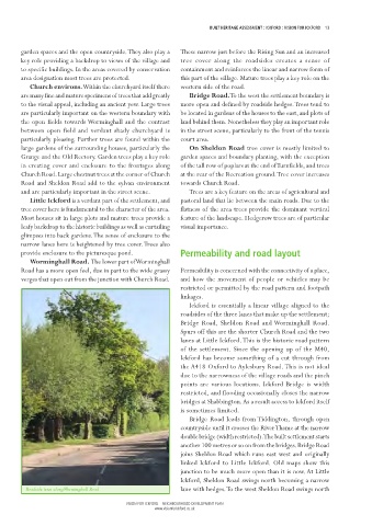
Worminghall Road. The lower part of Worminghall
Road has a more open feel, due in part to the wide grassy Permeability is concerned with the connectivity of a place,
verges that open out from the junction with Church Road. and how the movement of people or vehicles may be
restricted or permitted by the road pattern and footpath
linkages.
Ickford is essentially a linear village aligned to the
roadsides of the three lanes that make up the settlement;
Bridge Road, Sheldon Road and Worminghall Road.
Spurs off this are the shorter Church Road and the two
lanes at Little Ickford. This is the historic road pattern
of the settlement. Since the opening up of the M40,
Ickford has become something of a cut through from
the A418 Oxford to Aylesbury Road. This is not ideal
due to the narrowness of the village roads and the pinch
points are various locations. Ickford Bridge is width
restricted, and flooding occasionally closes the narrow
bridges at Shabbington. As a result access to Ickford itself
is sometimes limited.
Bridge Road leads from Tiddington, through open
countryside until it crosses the River Thame at the narrow
double bridge (width restricted). The built settlement starts
another 100 metres or so on from the bridges. Bridge Road
joins Sheldon Road which runs east west and originally
linked Ickford to Little Ickford. Old maps show this
junction to be much more open than it is now. At Little
Ickford, Sheldon Road swings north becoming a narrow
Roadside trees along Worminghall Road lane with hedges. To the west Sheldon Road swings north
VISION FOR ICKFORD – NEIGHBOURHOOD DEVELOPMENT PLAN
www.visionforickford.co.uk